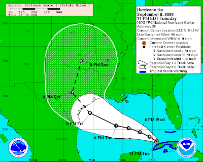
Hurricane Ike has entered the Gulf of Mexico and has begun to strengthen fairly quickly... An eye has reemerged almost immediately as it has exited Cuba... This is bad bad news in my personal opinion... It tells me that the core is not only intact, but actually STRONG.... For Ike to keep it's core like it has is VERY impressive and shows me the resiliency of this hurricane! I truly fear the end result for Ike... I still think Ike will strike near Corpus Christi, maybe a little north, as a strong Cat-3 if not a solid Cat-4... I also have to say that I don't think it's impossible for Ike to get to Cat-5 status as it heads towards Texas... There is still one big question about how the trough will affect Ike... It looks like Ike will make landfall before the trough pulls it hard north, but it's still going to be a close call... Personally I feel like Ike will stay more south and west because the ridge will hold strong.... Especially with a major hurricane pumping the ridge! Time will tell, but if I lived along the Texas coast up to Houston I would watch this storm very closely...
Unfortunately Ike reminds for of two horrific hurricanes that have hit Texas which was brought up by Joe Bastardi from accuweather.... The first being Hurricane Carla in 1961... Carla made landfall as a Cat-4 (931mb) near Port Lavaca with wind gusts up to 170mph... The storm surge was 22 feet and push inland in some places up to 10 miles! The second being the Indianola Hurricane of 1886... It made landfall as a strong Cat-4 with a pressure of 925mb... The 5th lowest pressure at landfall behind 1935 Labor Day, Camille, Andrew, and Katrina... This hurricane actually helped Galveston become the major port city of Texas until the Great 1900 hurricane destroyed it! I'm not saying Ike will get as strong as these two great America hurricanes but honestly it has the potential!!! This is a DANGEROUS situation, and if you live from Corpus Christi all the way to Houston you need to take this hurricane VERY seriously!!!


No comments:
Post a Comment