Tropical Storm Fay may not go down as a hurricane but it will go down as one of the most rain producing tropical storms to hit the US since Allison in 2001... Allison pounded the Houston area with near 40 inches of rain in some parts of SE Texas... By the way Allison is the only tropical storm to ever have it's named retired by the NHC... Hurricane Agnes in 1972 was a minimal hurricane at landfall in the Florida panhandle only to become one of the most rain producing storms for the North East US... It actually was the fist billion dollar hurricane in US history... Obviously not for its 75 mph winds at landfall but for its torrential rains that killed 48 people in Pennsylvania... Ironically both of these storms occurred in June!
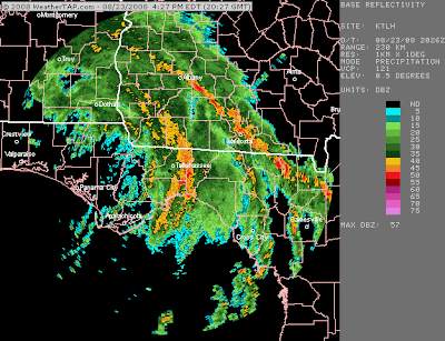
With Fay the totals to this point have been absolutely amazing across the north east coast of Florida... Melbourne Beach received 25.03", Cocoa Beach 24.19", and Satellite Beach 22.40"... Things along the panhandle of Florida are going down fast!!! The Tallahasee area has been getting pounded with reports already over 20 inches widespread across the region... Just look at the radar image out of KTLH.... Tallahassee's Leon County is really getting hit hard right now... With reports over 20 inches so far and another 12 inches plus expected you could see some areas receiving near 3 feet of rain... That's approaching tropical storm Allison levels!!!
Unfortunately things look to get worst before they get better... Fay is expected to keep moving agonizingly slow through the Panhandle of Florida, South Alabama, and South Mississippi... Eventually Fay should get picked up and start to accelerate north and east by Wednesday/Thursday of next week... The problem is by then we will be looking at rainfall totals across those areas well above 1 feet if not close to 2 feet!!! Please use extra caution when driving as only 2 feet of water can pick up your car! 6 inches of fast moving water can knock you off your feet! Thankfully the severe weather threat has been minimal with this storm, even though with any landfalling tropical cyclones there is still a threat even if it's minimal... To date there have been 8 tornadoes clustered around the Jacksonville, Fl metroplex...
With the tropics I'm going to wait until something develops before I start to do an in-depth analysis... Until we get a low level center to form it's extremely difficult to make any assumptions/forecasts... I will say that the two main threats 95L (northern disturbance) and 94L (southern disturbance) are developing in area that historically are not big time landfalling threats for the US... 95L looks to develop too far north and head out to sea, where 94L looks to develops too far south and head into the Yucatan/Central America... At this point it's impossible to say for sure what will happen, but either way it will be very interesting to see what happens!!!


No comments:
Post a Comment