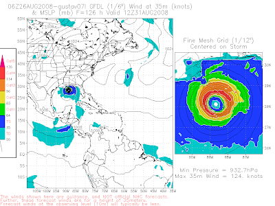
There is no doubt in my mind, Gustav is heading for the Gulf of Mexico... I felt pretty strong about this yesterday but I was hoping I would be wrong... Unfortunately it's not looking that way and my worst fears are coming true!!! Gustav is currently 981mb with 90mph sustained winds... It will interact with some land for the next couple of days but once it releases west LOOK OUT!!! 12z early track model guidance is remarkably clustered right now on western Cuba... It's honestly one of the best 120 hour agreements I have seen in a long time...
There is no doubt in my mind that Gustav will get into the Gulf of Mexico but from there it's a little tricky... Looking at both visible and water vapor imagery the ridge is building in fast to the east... I'm starting to wonder now if Gustav shoots the gap between the Yucatan and western Cuba which would only make things worse... From there it's just a question of whether the trough this weekend pulls Gustav to the north and towards the northern Gulf Coast, or whether the trough misses Gustav allowing this monster to head for Texas... That's really tough to say right now but if I had to pick one of those scenarios I would lean more towards a Texas threat, but again it's still too far out to say for sure!!! I will say the 6z GFDL is showing a scary scenario for the New Orleans area... I pray that's wrong... We will see if the GFS has it's common right bias/error... I personally feel it will and that's why I'm leaning more with a Texas landfall than a northern Gulf coast landfall... Plus teleconnections tell me the trough should be fairly north, but again it's going to be really close! I'll have a detailed update later tonight!!! I hate to say it, but I'm praying for the best but expecting the worst at this point!!! This really looks BAD!!!


No comments:
Post a Comment